![](/images/other/stat-length.png)
![Tocht Te voet Le Gâvre - parcours en forêt du Gavre par la Magdeleine - Photo](https://media.geolcdn.com/t/1900/400/ext.pjpeg?maxdim=2&url=https%3A%2F%2Fstatic1.geolcdn.com%2Fsiteimages%2Fupload%2Ffiles%2F1545311037marcheuse_200dpi.jpg)
parcours en forêt du Gavre par la Magdeleine
Pascale EZAN-PENOT
Gebruiker
![Lengte](/images/other/stat-length.png)
Lengte
11,8 km
![Max. hoogte](https://static1.geolcdn.com/siteimages/upload/files/1508320355ic_sort_altitude_max_24dp.png)
Max. hoogte
54 m
![Positief hoogteverschil](https://static1.geolcdn.com/siteimages/upload/files/1508320355ic_sort_den_pos_24dp.png)
Positief hoogteverschil
113 m
![Km-Effort](/images/other/stat-length.png)
Km-Effort
13,3 km
![Min. hoogte](https://static1.geolcdn.com/siteimages/upload/files/1508320355ic_sort_altitude_min_24dp.png)
Min. hoogte
27 m
![Negatief hoogteverschil](https://static1.geolcdn.com/siteimages/upload/files/1508320355ic_sort_den_neg_24dp.png)
Negatief hoogteverschil
113 m
![Boucle](https://static1.geolcdn.com/siteimages/upload/files/16400158638029165_repeat_loop_refresh_sync_direction_icon.png)
Boucle
Ja
Datum van aanmaak :
2022-10-31 16:50:18.016
Laatste wijziging :
2022-10-31 17:10:47.651
![Te voet](https://static1.geolcdn.com/sitytour/trail-icons/100.png)
3h00
Moeilijkheid : Gemakkelijk
![Stappen](https://static1.geolcdn.com/sitytour/trail-icons/101.png)
3h00
Moeilijkheid : Moeilijk
![Scan deze QR-code om de tocht te openen in de SityTrail-applicatie](https://capi.geolives.com/qq0zvz2zws4bq2lad0pu/sitytour/trails/3442597/qr.png?size=200)
Gratisgps-wandelapplicatie
Over ons
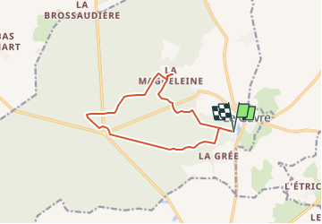
Tocht Te voet van 11,8 km beschikbaar op Pays de la Loire, Loire-Atlantique, Le Gâvre. Deze tocht wordt voorgesteld door Pascale EZAN-PENOT.
Beschrijving
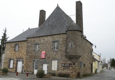
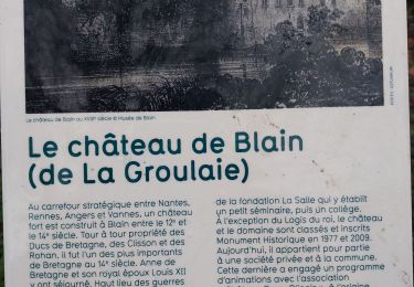
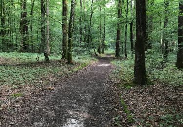
Petit parcours en forêt du Gavre et détour par la Magdeleine pour découvir l'histoire du hameau et de sa Chapelle -
Plaatsbepaling
Land:
France
Regio :
Pays de la Loire
Departement/Provincie :
Loire-Atlantique
Gemeente :
Le Gâvre
Locatie:
Unknown
Vertrek:(Dec)
Vertrek:(UTM)
593882 ; 5263330 (30T) N.
Opmerkingen
Wandeltochten in de omgeving
![Tocht Te voet Le Gâvre - Le Chêne de la Messe - Photo](https://media.geolcdn.com/t/375/260/07e3cf84-6a15-410b-8836-4f65b56c35a6.jpeg&format=jpg&maxdim=2)
![Te voet Te voet](https://static1.geolcdn.com/sitytour/trail-icons/100.png)
Le Chêne de la Messe
Te voet
Gemakkelijk
Le Gâvre,
Pays de la Loire,
Loire-Atlantique,
France
![](/images/other/stat-length.png)
6,6 km | 7,5 km-effort
1h 42min
![](https://static1.geolcdn.com/siteimages/upload/files/16400158638029165_repeat_loop_refresh_sync_direction_icon.png)
Ja
![Tocht Stappen Le Gâvre - 7.8.2019 Forêt du Gavre - Photo](https://media.geolcdn.com/t/375/260/f9cf14e8-928c-443f-a037-337d0befb490.jpg&format=jpg&maxdim=2)
![Stappen Stappen](https://static1.geolcdn.com/sitytour/trail-icons/101.png)
7.8.2019 Forêt du Gavre
Stappen
Medium
Le Gâvre,
Pays de la Loire,
Loire-Atlantique,
France
![](/images/other/stat-length.png)
22 km | 25 km-effort
7h 48min
![](https://static1.geolcdn.com/siteimages/upload/files/16400158638029165_repeat_loop_refresh_sync_direction_icon.png)
Ja
![Tocht Stappen Le Gâvre - forêt du Gavre - Photo](https://media.geolcdn.com/t/375/260/9b5efb39-468e-45dd-bfa8-e0594305ea10.jpg&format=jpg&maxdim=2)
![Stappen Stappen](https://static1.geolcdn.com/sitytour/trail-icons/101.png)
forêt du Gavre
Stappen
Medium
Le Gâvre,
Pays de la Loire,
Loire-Atlantique,
France
![](/images/other/stat-length.png)
7,6 km | 8,6 km-effort
2h 45min
![](https://static1.geolcdn.com/siteimages/upload/files/16400158638029165_repeat_loop_refresh_sync_direction_icon.png)
Ja
![Tocht Stappen Blain - la voie verte Blain à Bouvron - Photo](https://media.geolcdn.com/t/375/260/9575372d-80b3-4752-9809-040bdd99dc34.jpg&format=jpg&maxdim=2)
![Stappen Stappen](https://static1.geolcdn.com/sitytour/trail-icons/101.png)
la voie verte Blain à Bouvron
Stappen
Medium
Blain,
Pays de la Loire,
Loire-Atlantique,
France
![](/images/other/stat-length.png)
10,3 km | 11,1 km-effort
3h 6min
![](https://static1.geolcdn.com/siteimages/upload/files/16400158638029165_repeat_loop_refresh_sync_direction_icon.png)
Ja
![Tocht Stappen Le Gâvre - 07.08.2019 - GÂVRE nord et Clégreuc - Photo](https://media.geolcdn.com/t/375/260/50e63918-d990-4d20-974b-f7cef55e5682.jpg&format=jpg&maxdim=2)
![Stappen Stappen](https://static1.geolcdn.com/sitytour/trail-icons/101.png)
07.08.2019 - GÂVRE nord et Clégreuc
Stappen
Medium
Le Gâvre,
Pays de la Loire,
Loire-Atlantique,
France
![](/images/other/stat-length.png)
24 km | 27 km-effort
8h 8min
![](https://static1.geolcdn.com/siteimages/upload/files/16400158638029165_repeat_loop_refresh_sync_direction_icon.png)
Ja
![Tocht Paard Le Gâvre - gavre072016 - Photo](https://media.geolcdn.com/t/375/260/ext.jpg?maxdim=2&url=https%3A%2F%2Fservices.sitytrail.com%2FGeolivesWS%2FDownloadMedia.ashx%3FTrailID%3D606974%26Media%3Dfix__20160701105728.jpg)
![Paard Paard](https://static1.geolcdn.com/sitytour/trail-icons/300.png)
gavre072016
Paard
Heel gemakkelijk
Le Gâvre,
Pays de la Loire,
Loire-Atlantique,
France
![](/images/other/stat-length.png)
32 km | 36 km-effort
4h 36min
![](https://static1.geolcdn.com/siteimages/upload/files/16400158638029165_repeat_loop_refresh_sync_direction_icon.png)
Ja
![Tocht Paard Le Gâvre - gavre juillet 2016 - Photo](https://media.geolcdn.com/t/375/260/ext.jpg?maxdim=2&url=https%3A%2F%2Fservices.sitytrail.com%2FGeolivesWS%2FDownloadMedia.ashx%3FTrailID%3D591466%26Media%3Dfix__20160701164833.jpg)
![Paard Paard](https://static1.geolcdn.com/sitytour/trail-icons/300.png)
gavre juillet 2016
Paard
Heel gemakkelijk
Le Gâvre,
Pays de la Loire,
Loire-Atlantique,
France
![](/images/other/stat-length.png)
31 km | 35 km-effort
4h 31min
![](https://static1.geolcdn.com/siteimages/upload/files/16400158638029165_repeat_loop_refresh_sync_direction_icon.png)
Ja
![Tocht Auto Le Gâvre - 2024-12-21 Le Gavre RB - Photo](https://media.geolcdn.com/t/375/260/ext.jpg?maxdim=2&url=https%3A%2F%2Fstatic1.geolcdn.com%2Fsiteimages%2Fupload%2Ffiles%2F15247431544x4.jpg)
![Auto Auto](https://static1.geolcdn.com/sitytour/trail-icons/401.png)
2024-12-21 Le Gavre RB
Auto
Le Gâvre,
Pays de la Loire,
Loire-Atlantique,
France
![](/images/other/stat-length.png)
40 km | 45 km-effort
3h 50min
![](https://static1.geolcdn.com/siteimages/upload/files/16400158638029165_repeat_loop_refresh_sync_direction_icon.png)
Neen
![Tocht Auto Le Gâvre - 2024-10-29 RB l eGavre - Photo](https://media.geolcdn.com/t/375/260/ext.jpg?maxdim=2&url=https%3A%2F%2Fstatic1.geolcdn.com%2Fsiteimages%2Fupload%2Ffiles%2F15247431544x4.jpg)
![Auto Auto](https://static1.geolcdn.com/sitytour/trail-icons/401.png)
2024-10-29 RB l eGavre
Auto
Le Gâvre,
Pays de la Loire,
Loire-Atlantique,
France
![](/images/other/stat-length.png)
24 km | 26 km-effort
2h 41min
![](https://static1.geolcdn.com/siteimages/upload/files/16400158638029165_repeat_loop_refresh_sync_direction_icon.png)
Ja